If you’re reading this blog, then somewhere around your house, you probably have a map of your own private D&D world. Take a look at it.
Now delete everything in the middle. Just leave a half-inch strip along the edges.
What’s left in that half-inch strip? Is it all ocean? That’s how mine looks. I’m starting to think that’s a problem.
I’m coming to think that maps are better when they have more seas, fewer oceans. The Mediterranean and the English Channel are interesting in a way that the Atlantic and Pacific are not.
For one thing, I think land-heavy maps just look cooler. Maybe it’s because well-defined continents are really easy to read at a glance. Winding inland seas, though, stagger the brain. A staggered brain is good. It’s one step away from Wonder.
Let’s say you eventually decide to add another big continent, culturally isolated from the starting area: Kara-Tur, say. Many D&D campaigns have Renaissance-level naval technology (the Renaissance has cooler ships), which means that oceans are not much of a barrier to trade and exploration. An impassable desert might be a more plausible barrier.
There’s also something about a water-surrounded continent that throws a net around the whole campaign world. The players, and maybe the DM, might not think of exploring beyond its boundaries. On the other hand, areas of land drifting off the map, even featureless areas like impassable mountains, frozen wastes and trackless deserts, suggest who knows what wonders on the other side?
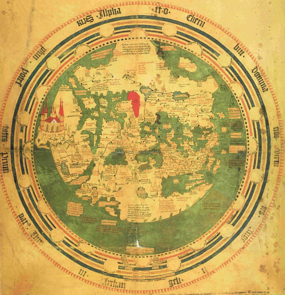
 Check out this awesome map of Earth from 1448. Although it’s basically encircled by sea, it does have lots of complex, winding inland seas. It does fill me with a sense of wonder. It takes you a while to even see that it’s Earth: you can eventually identify Europe, upside-down, but the rest of the world is pretty conjectural. And look at the details! Look how red the Red Sea is! Look at the cute little towns and castles! And look at that awesome city on the left side! Apparently that’s Paradise – right on the world map. Come to think of it, the edges of the world map is a great place to put all the Planes.


check out this map, which inverts earth’s land and water:
http://twentytwowords.com/2011/02/01/a-world-map-that-inverts-land-and-sea/
Good point about desert being more mysterious/evocative somehow! I think the map of Oz or Narnia –or maybe both–has a bunch of desert around it, and you get the sense that if yoy could cross it you could get to Kansas. After all, you can fly there in a balloon or a tornado. I think an ocean can do that, too–renaissance-level naval technology results in some pretty amazing adventures to unknown cultures, but it only makes them possible, not easy. We feel politically uncomfortable about columbus day, but (as we said in the Scholastic magazines, running out of anything else you can say about Columbus) it was a cool, scary trip. Also the Dawn Treader. Maybe to make the ocean more exciting on the map it helps to indicate the stuff the cartographer thinks is out there–dragons, Ultima Thule, the resting place of the elves, El Dorado?