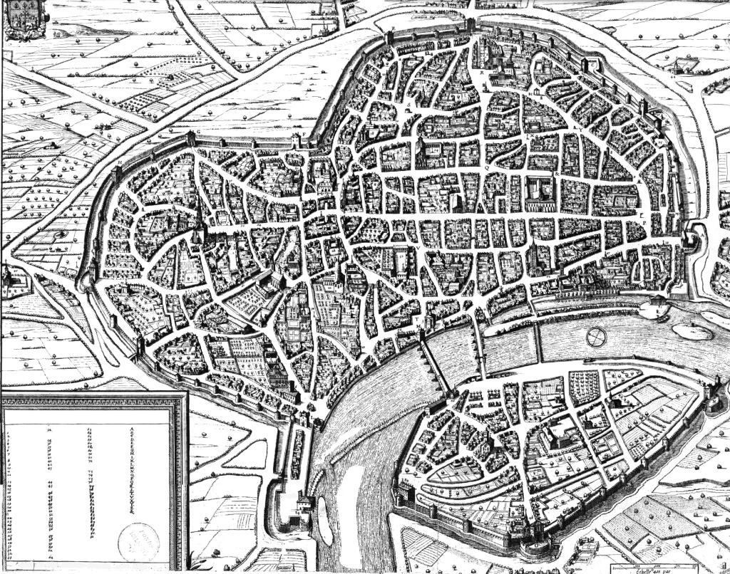
My dad has this map of the city of Toulouse in 1631. I don’t know where he got it. Maybe he picked it up in Toulouse in 1631.
It’s a super D&D-style map. It’s one of those Greyhawk-like maps which shows every building in the city. Furthermore, it’s numerically keyed. The original map labels 100 or so locations in the city – in French of course. I’ve deleted all the key text and street/river names so you can write your own.
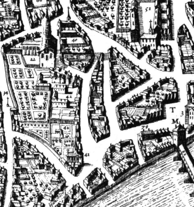
Here’s a representative neighborhood:
The numbers are scattered haphazardly around the map, so it’s pretty hard to look up the location of, say, 36. Give them a break. In 1631, D&D was in its infancy. The numbers are also tiny: the best-resolution map I could find is just good enough to read the numbers, but could be better.
So you want to drop this map into your campaign world. What kind of city does it represent?
According to Wikipedia, Toulouse in the 1690s had 40,000 inhabitants. In 1631 that was probably a little lower. I estimate that this map shows about 5 or 6 thousand houses. You could plausibly fit that population into that number of buildings, so this map could actually show every house in what the 3e DMG would classify as a Large City or even a Metropolis. This could be your big home base city, and you can key every church, palace, inn, and NPC’s home, if you so desire.
What’s the scale of the city? I left the charming medieval French scale bar. Distance is measured in “pais”, or paces. A pace was 30 inches, which is a great D&D number because two paces is exactly 5 feet. Toulouse is about two miles across in its widest dimension.
Also interesting to note: city blocks in 17th century Toulouse were a big ring of buildings surrounding some outside space: orchards, gardens, or common pasture. If this map is to be believed, everyone had a backyard. That observation matches with similar medieval city maps: check out Brussels. Sure, these cities feature filth in the streets, cramped alleys, and overhanging second floors, but there are lots of public squares and semi-private green places.
Another thing: Toulouse’s shape. It looks like a heart, broken by the river running through it. City of the broken heart?
Here’s a one-page PDF of the map. It might be better served by a two-page spread with larger, less randomly placed numbers. I leave that as an exercise to the DM.


This view from an angled perspective is interesting too… http://www.archives.toulouse.fr/anciensite/reperes/Site_Plans/html/ficheberey.htm
And an image search for Tavernier gives a bunch of other good maps (some regional).
Check out this siege map! http://gallica.bnf.fr/ark:/12148/btv1b550023907.r=tavernier.langEN
Looks like Silverymoon. Although there have been a lot of D&D maps apparently designed with the method “draw a blob for the wall, looks boring, how about a river through it, make the river curve so it looks organic, add some bridges”.
By the way, thank you for the editing work removing text and such. That is not easy.
I find these detailed historic maps endlessly fascinating. Especially when you stop to consider there was absolutely no way for the artist to get that perspective on the city! Those maps must have been created by surveying the city at ground level and then imagining the bird’s eye view. We are so jaded nowadays with photos from satellites and airplanes that it’s easy to forget that apart from cities in valleys, mapmakers would never have been able to see those perspectives with their eyes.
Hello, this is a detail, but a priori, in the case of this map, a “pas” = 0.624 meters (unit measure in “L’Ancien Régime” in France).
Chris
So, a “pas” = 24.5669291 inches
Sorry !
Chris
Hi Paul, I’m writing a novel set partly in 17th Century Toulouse and I was wondering if you could upload or send me a photo the original map, without the places omitted? It’s really hard to find good in-depth historical info with the homogenous blob that is Google. I have no intention of publishing it in any way or taking credit for it. I just need a good source!
Very interesting. Do you think this map is correct??